MONDAY, AUGUST 24, 10:30 AM ... Although most of the wildfires in northwestern California are now over 50 percent contained, the River (Denny) and Gasquet (northeast of Crescent City) complexes are less than 25 percent contained.
Inversions are expected to lift across most of the region this afternoon, which should help air support, but will likely increase fire activity. Gusty winds at higher elevations are also a concern.
The Air Quality Forecast was published at 9:45 this morning and is HERE.
Acres = 16,187
Containment = 17%
Personnel = 637
There is a Public Meeting TODAY, 7 PM, at the Crescent City Fire Protection District Fire Station (255 West Washington Road).
South Fork Road (off Highway 199) is limited to residential and fire traffic only.
A marine weather pattern this morning will moderate fire activity but is expected to lift this afternoon and - along with winds gusting over 15 miles per hour - increase fire activity into the evening.
Latest information on road closures, evacuations and support services are HERE.
~*~*~*~*~*~*~*~*~*~*~*~*~*~*~*~*~*~*~*
DENNY (River Complex)
Acres = 53,967
Containment = 24%
Personnel = 602
The southeastern flank is now burning approximately 2 miles from Highway 299 near Hayden Flat/Del Loma. This is now the primary focus of firefighters in order to keep the highway open and protect structures around Del Loma. The western flank of the complex is now contained.
Gusty winds over 20 miles per hour are expected this afternoon.
Latest information on road closures, evacuations and support services are HERE.
~*~*~*~*~*~*~*~*~*~*~*~*~*~*~*~*~*~*~*

Acres = 25,071
Containment = 55%
Personnel = 792
There is a Public Meeting TODAY, 4 PM, at the Hyampom Fire Station.
A Clean Air Center is now open at the Haympom Community Center.
Skunk Ranch, Bar 717, and Road 3N46 are ALL under MANDATORY EVACUATION.
Fire continues to back down the western flank of the Castle Fire toward the river with structure protection teams in place. Helicopters have been deployed to slow the southern advance of the Pattison Fire near Hayfork Creek.
For more on evacuations, road closures, and other support services click HERE.
~*~*~*~*~*~*~*~*~*~*~*~*~*~*~*~*~*~*~*~*
HAYFORK (Fork Complex)
Acres = 36,499
Containment = 85%
Personnel = 852
Most of the fire activity has moderated. Primary focus is the Shiell Fire in the Chanchelulla Wilderness. Infrared mapping shows significant heat within the interior of the Peak and Shiell Fires. Interior fires should be able to burn out with the help of warmer temperatures, humidity below 30 percent, less smoke and more sun exposure.
Up-to-date information on road closures, evacuations, and support services HERE.
~*~*~*~*~*~*~*~*~*~*~*~*~*~*~*~*~*~*~*~*
ROUTE COMPLEX & MAD RIVER COMPLEX
The Ruth Lake fires (Mad River Complex) have burned 33,863 acres and are at 54 percent containment. The Route Complex has burned 35,076 acres and is at 42 percent containment.
Highway 36 is now re-opened.
These fires are now under a single command with more information available HERE.
~*~*~*~*~*~*~*~*~*~*~*~*~*~*~*~*~*~*~*~*~*
SOME USEFUL MAPS:
MAP OF CALIFORNIA WILDFIRES (as of Monday, August 24, 8 AM)

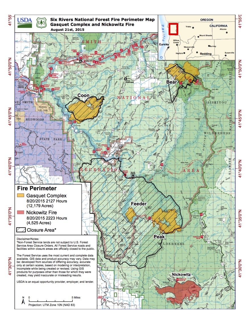
GASQUET & NICKOWITZ WILDFIRES (as of August 20, 2015)


